
| Pinners Point Interchange Construction Photos - February 2004 |
The following photos show various aerial views of the Pinners Point Interchange construction, including the new Port Norfolk Connector freeway bridge under construction, the existing Midtown Tunnel approach highway under construction, the West Norfolk Bridge, the Port Norfolk neighborhood in the city of Portsmouth, the Portsmouth Marine Terminal, the Elizabeth River Western Branch, and the main section of the Elizabeth River.
These photos were taken on February 19, 2004 by the Virginia Department of Transportation, and are posted here with their permission. Click on the photo to get a large version of the photo. In later versions of Netscape and Internet Explorer, you probably will need to use Full Screen mode (the F11 key can be utilized to swap back and forth between Full Screen and Regular) to see the full size of the large photo without browser-induced image shrinkage. The large photos are BIG, with the sizes ranging from 335 to 583 kilobytes, with most of them being under 500 kilobytes. With a broadband or network Internet connection each photo will download within seconds, but with a dial-up Internet connection it will be slow.
 |
Pinners Point Interchange construction in center of photo, with Port Norfolk neighborhood in upper left of photo. Looking west. |
 |
Pinners Point Interchange construction in center of photo, with Port Norfolk neighborhood in upper part of photo, with Portsmouth Marine Terminal in lower right of photo, with existing Midtown Tunnel approach highway in lower left of photo. Looking west. |
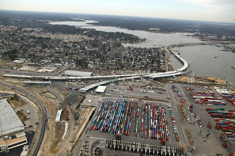 |
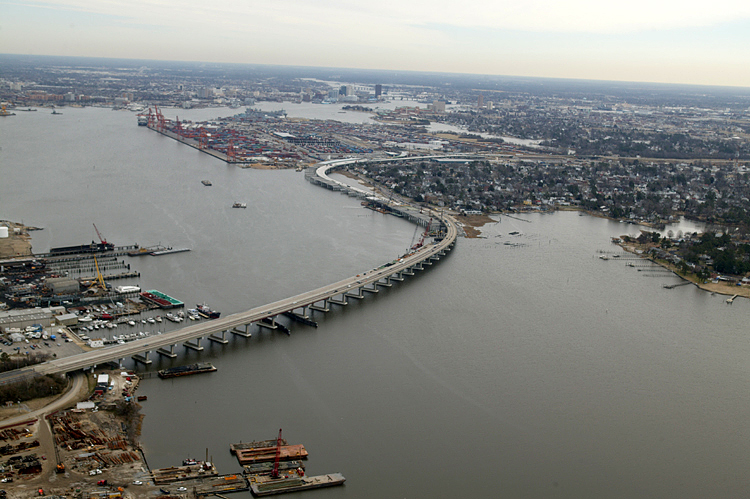
Pinners Point Interchange construction in left of photo, with Port Norfolk neighborhood in upper left of photo, with the marine terminal in lower right of photo, with existing Midtown Tunnel approach highway in lower left of photo, with West Norfolk Bridge and Elizabeth River Western Branch in upper part of photo. Looking west. |
 |
Pinners Point Interchange construction in left of photo, with Port Norfolk neighborhood in upper left of photo, with the marine terminal in lower part of photo, with West Norfolk Bridge and Elizabeth River Western Branch in upper part of photo. Looking west. |
 |
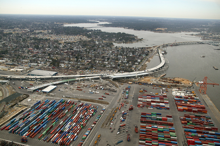
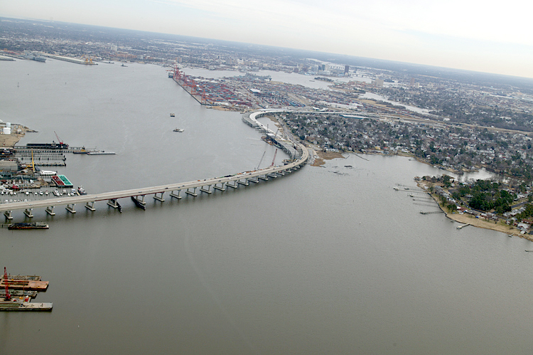
Pinners Point Interchange construction mostly off left edge of photo, with Port Norfolk neighborhood in upper left of photo, with the marine terminal in lower part of photo, with West Norfolk Bridge and Elizabeth River Western Branch in upper part of photo, showing closer view of new Port Norfolk Connector freeway bridge under construction over river. Looking west. |
 |
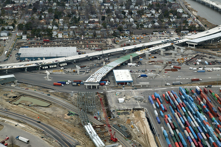
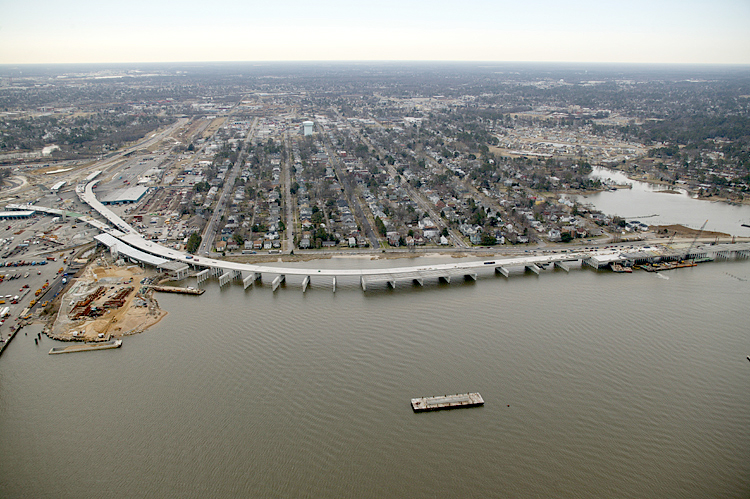
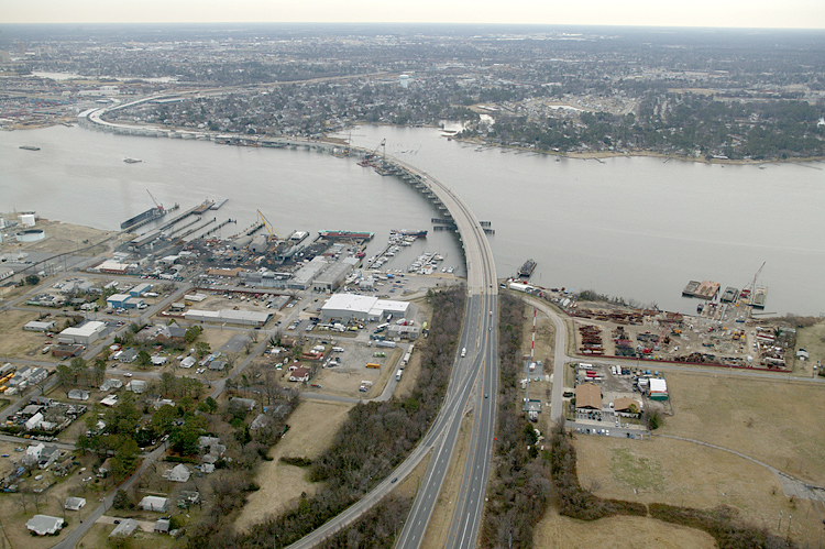
Pinners Point Interchange construction in center of photo, with Port Norfolk neighborhood mostly off right edge of photo, with the marine terminal in lower left part of photo, with Martin Luther King Freeway reconstruction in upper right of photo. Looking south. |
 |
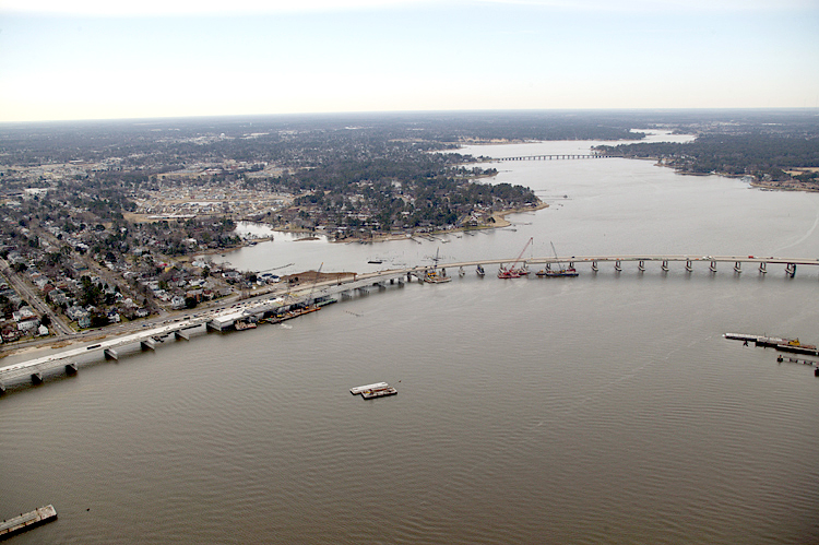
Pinners Point Interchange construction in left center of photo, with Port Norfolk neighborhood in upper right of photo, with the marine terminal in lower part of photo, with Martin Luther King Freeway reconstruction in upper left of photo. Looking south. |
 |
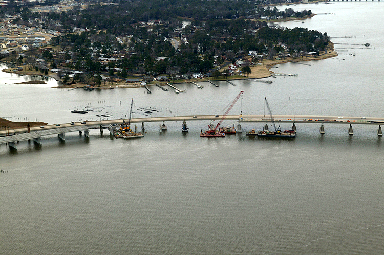
Pinners Point Interchange construction off left edge of photo, with Port Norfolk neighborhood in upper part of photo, with new Port Norfolk Connector freeway bridge under construction in center of photo, with West Norfolk Bridge and Elizabeth River Western Branch in upper right corner of photo. The south end of the West Norfolk Bridge is being reconstructed and realigned so that it will make a seamless freeway connection with the Port Norfolk Connector bridge. Looking south. |
 |
Pinners Point Interchange construction off left edge of photo, with Port Norfolk neighborhood in upper left part of photo, with new Port Norfolk Connector freeway bridge under construction in center of photo, with south end of the West Norfolk Bridge in right corner of photo. Looking south. |
 |
Pinners Point Interchange construction off left edge of photo, with Port Norfolk neighborhood in upper left part of photo, with new Port Norfolk Connector freeway bridge under construction in center of photo, with south end of the West Norfolk Bridge in right corner of photo. Looking south. |
 |
Pinners Point Interchange construction at left edge of photo, with Port Norfolk neighborhood in center part of photo, with new Port Norfolk Connector freeway bridge under construction in center of photo, with south end of the West Norfolk Bridge in right side of photo. Looking south. |
 |
Port Norfolk
neighborhood in left center part of photo, with new Port Norfolk Connector
freeway bridge under construction in left of photo, with West Norfolk Bridge
and Elizabeth River Western Branch in upper left part of photo.
The south end of the West Norfolk Bridge is being reconstructed and realigned so that it will make a seamless freeway connection with the Port Norfolk Connector bridge. Looking south. |
 |
Closer
view showing where the south end of the West Norfolk Bridge is being reconstructed
and realigned so that it will make a seamless freeway connection with the
under construction Port Norfolk Connector bridge.
Looking south. The completed VA-164 freeway will no longer provide highway access between the West Norfolk Bridge and the Port Norfolk neighborhood. The new Pinners Point Interchange will provide full local access to all three legs of the freeway complex, just east of the Port Norfolk neighborhood. It was the main consensus among the citizens in the Port Norfolk neighborhood, to restrict access so as to eliminate the through traffic, which comprises about 80% of the traffic that currently passes through the neighborhood. |
 |
VA-164 Western Freeway in center of photo, with West Norfolk section of the City of Portsmouth in lower part of photo, with West Norfolk Bridge and Elizabeth River Western Branch in center of photo, with Port Norfolk neighborhood in upper part of photo, with new Port Norfolk Connector freeway bridge under construction in upper left of photo. Looking southeast. |
 |
West Norfolk section of Portsmouth in lower part of photo, with West Norfolk Bridge and Elizabeth River Western Branch in center of photo, with Port Norfolk neighborhood in upper part of photo, with new Port Norfolk Connector freeway bridge under construction in upper left of photo, with Pinners Point Interchange construction in upper left of photo. Looking east. |
 |
West Norfolk section of Portsmouth in lower left of photo, with West Norfolk Bridge and Elizabeth River Western Branch in center of photo, with Port Norfolk neighborhood in center of photo, with new Port Norfolk Connector freeway bridge under construction in center of photo, with Pinners Point Interchange construction in upper center of photo. Looking east. |
 |
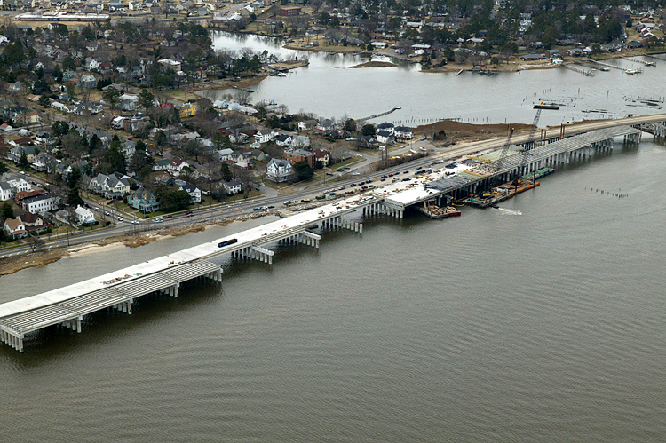
West Norfolk Bridge and Elizabeth River Western Branch in center of photo, with Port Norfolk neighborhood in center of photo, with new Port Norfolk Connector freeway bridge under construction in center of photo, with Pinners Point Interchange construction in upper center of photo. Looking east. |
 |
West Norfolk Bridge and Elizabeth River Western Branch in center of photo, with Port Norfolk neighborhood in right of photo, with new Port Norfolk Connector freeway bridge under construction in center of photo, with Pinners Point Interchange construction in upper right of photo, with the Portsmouth Marine Terminal in upper right of photo. Looking east. |
 |
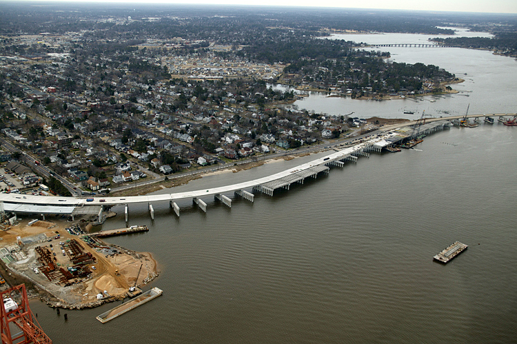
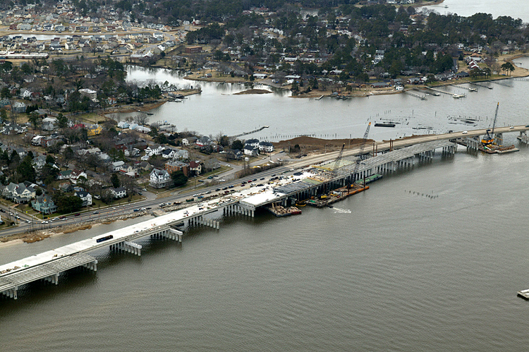
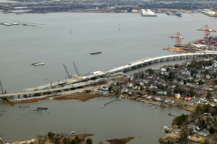
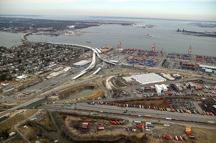
West Norfolk Bridge and Elizabeth River Western Branch in lower left of photo, with Port Norfolk neighborhood in right center of photo, with new Port Norfolk Connector freeway bridge under construction in center of photo, with Pinners Point Interchange construction in upper right of photo, with the marine terminal in upper right of photo, with main section of the Elizabeth River in upper part of photo. The south end of the West Norfolk Bridge is being reconstructed and realigned so that it will make a seamless freeway connection with the Port Norfolk Connector bridge. Looking east. |
 |
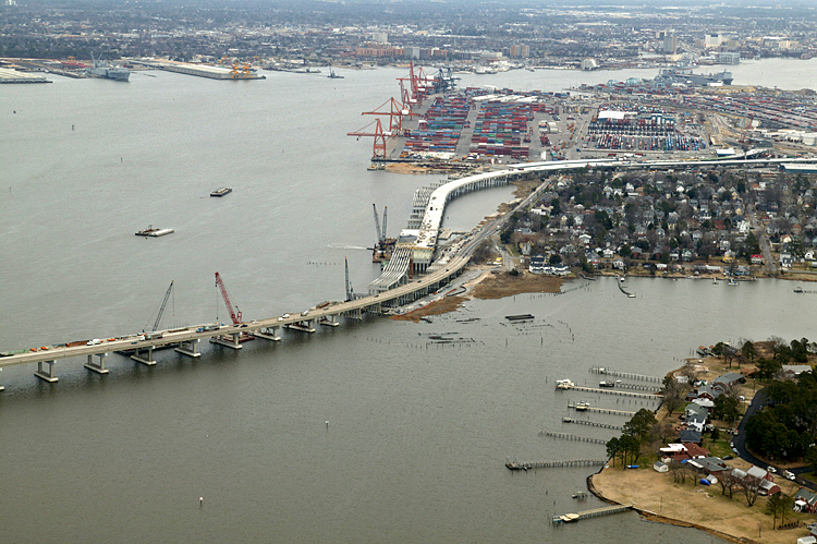
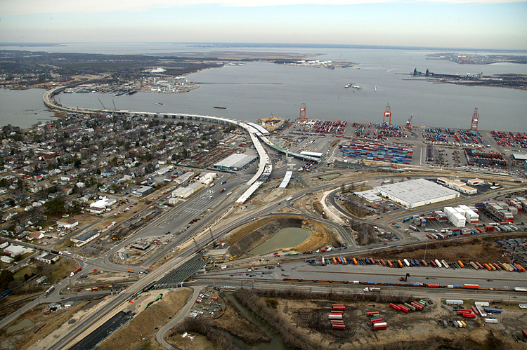
Port Norfolk neighborhood in right center of photo, with new Port Norfolk Connector freeway bridge under construction in center of photo, with main section of the Elizabeth River in upper part of photo. The south end of the West Norfolk Bridge is being reconstructed and realigned so that it will make a seamless freeway connection with the Port Norfolk Connector bridge. Looking east. |
 |
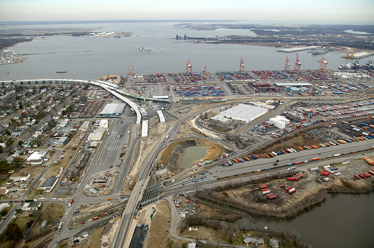
Port Norfolk neighborhood in center of photo, with new Port Norfolk Connector freeway bridge under construction in center of photo, with main section of the Elizabeth River in upper part of photo, with Pinners Point Interchange construction in upper right of photo, with the marine terminal in upper right of photo. Looking northeast. |
 |
Port Norfolk neighborhood in lower right of photo, with new Port Norfolk Connector freeway bridge under construction in center of photo, with main section of the Elizabeth River in upper part of photo. Looking northeast. |
 |
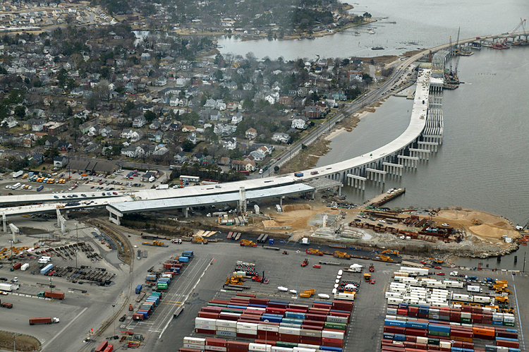
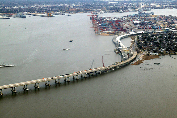
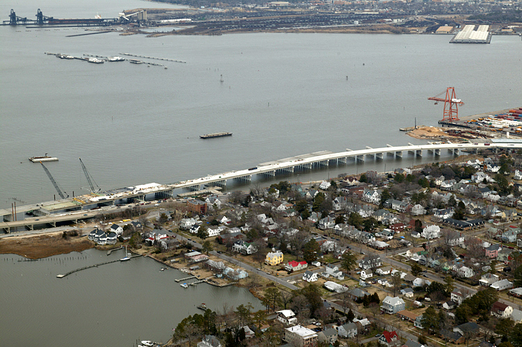
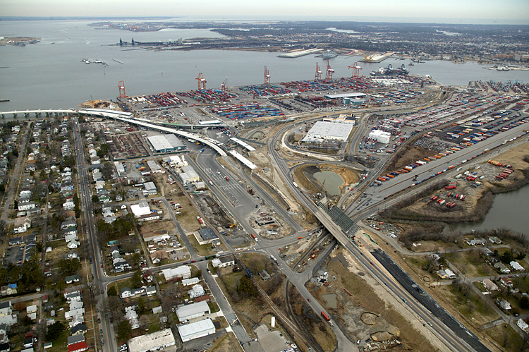
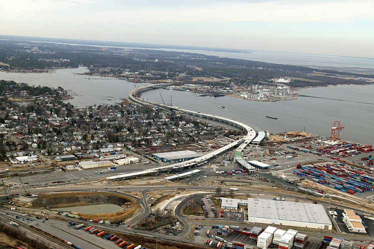
Port Norfolk neighborhood in lower part of photo, with new Port Norfolk Connector freeway bridge under construction in center of photo, with main section of the Elizabeth River in upper part of photo, with Pinners Point Interchange construction in upper right of photo, with Portsmouth Marine Terminal in upper right of photo. Looking east. |
 |
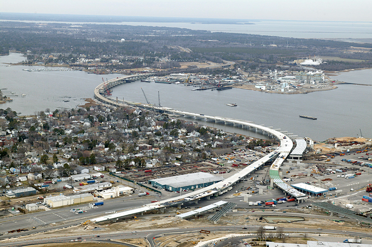
Port Norfolk neighborhood in lower part of photo, with main section of the Elizabeth River in upper part of photo, with Pinners Point Interchange construction in upper part of photo, with the marine terminal in upper right of photo. Looking east. |
 |
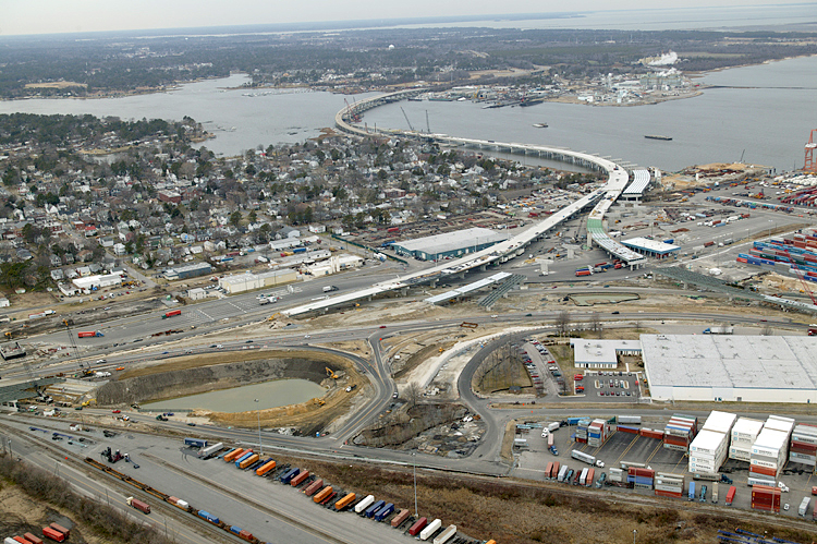
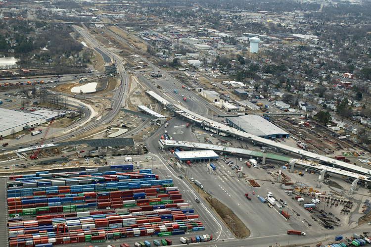
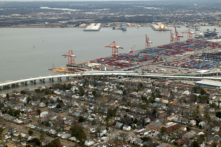
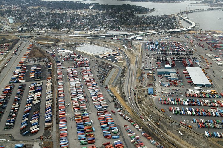
Port Norfolk neighborhood in lower left part of photo, with main section of the Elizabeth River in upper part of photo, with Pinners Point Interchange construction in center of photo, with the marine terminal in upper part of photo, with MLK Freeway widening in lower right of photo. Looking north. |
 |
Port Norfolk neighborhood in lower left part of photo, with main section of the Elizabeth River in upper part of photo, with new Port Norfolk Connector freeway bridge under construction in left center of photo, with Pinners Point Interchange construction in center of photo, with the marine terminal in upper part of photo, with MLK Freeway widening in lower right of photo. Looking north. |
 |
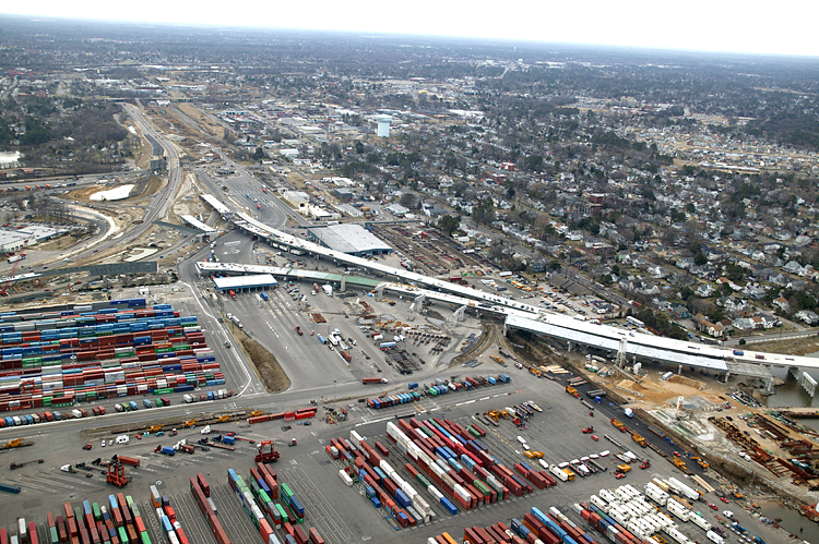
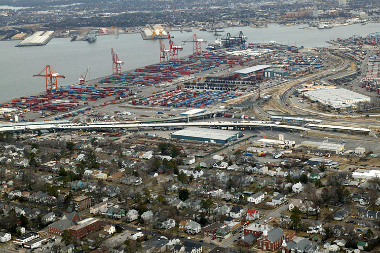
Port Norfolk
neighborhood in lower left part of photo, with main section of the Elizabeth
River in upper part of photo, with new Port Norfolk Connector freeway bridge
under construction in left center of photo, with Pinners Point Interchange
construction in center of photo, with the marine terminal in upper
part of photo, with MLK Freeway widening in lower part of photo. Looking north.
In the last 4 photos, the helicopter with the photographer has been flying from west to east, and continues doing that for the next 5 photos. |
 |
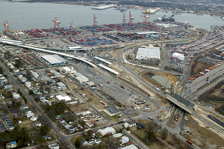
Port Norfolk neighborhood in left part of photo, with main section of the Elizabeth River in upper part of photo, with new Port Norfolk Connector freeway bridge under construction in left center of photo, with Pinners Point Interchange construction in center of photo, with the marine terminal in middle left of photo, with MLK Freeway widening in lower left of photo. Looking northwest. |
 |
Port Norfolk neighborhood in left part of photo, with main section of the Elizabeth River in upper part of photo, with new Port Norfolk Connector freeway bridge under construction in left center of photo, with Pinners Point Interchange construction in center of photo, with the marine terminal in middle right of photo, with MLK Freeway widening in lower left of photo. Looking northwest. |
 |
Port Norfolk neighborhood in left part of photo, with main section of the Elizabeth River in right part of photo, with new Port Norfolk Connector freeway bridge under construction in center part of photo, with West Norfolk Bridge and Elizabeth River Western Branch in left center of photo, with Pinners Point Interchange construction in lower center of photo, with MLK Freeway widening in lower left of photo. Looking northwest. |
 |
Port Norfolk neighborhood in left part of photo, with main section of the Elizabeth River in upper right part of photo, with new Port Norfolk Connector freeway bridge under construction in center of photo, with Pinners Point Interchange construction in center of photo, with the marine terminal in middle right of photo, with MLK Freeway widening in lower left of photo. Looking northwest. |
 |
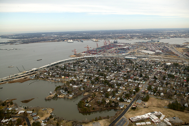
Port Norfolk neighborhood in upper left part of photo, with new Port Norfolk Connector freeway bridge under construction in upper right of photo, with West Norfolk Bridge and Elizabeth River Western Branch in upper right of photo, with Pinners Point Interchange construction in center of photo, with the marine terminal in lower part of the photo. The highway in the lower right of the photo, is the Midtown Tunnel approach highway. Looking west. |
Lead article Parallel Midtown Tunnel / Pinners Point Interchange / Martin Luther King Freeway Extension
Copyright © 2004-2006 by Scott Kozel. All rights reserved. Reproduction, reuse, or distribution without permission is prohibited.
By Scott M. Kozel, Roads to the Future
(Created 5-1-2004, minor update 3-1-2005, files moved to pennways on 2-1-2006)