
| Pinners Point Interchange Construction Photos - December 2004 |
The following photos show various aerial views of the Pinners Point Interchange construction, including the new Port Norfolk Connector freeway bridge under construction, the existing Midtown Tunnel approach highway under construction, the West Norfolk Bridge, the Port Norfolk neighborhood in the city of Portsmouth, the Portsmouth Marine Terminal, the Elizabeth River Western Branch, and the main section of the Elizabeth River.
These photos were taken on December 17, 2004 by the Virginia Department of Transportation, and are posted here with their permission and I utilized Adobe PhotoDeluxe Business Edition to brighten all the photos and to align and crop some of the photos. Click on the photo to get a large version of the photo. In later versions of Netscape and Internet Explorer, you probably will need to use Full Screen mode (the F11 key can be utilized to swap back and forth between Full Screen and Regular) to see the full size of the large photo without browser-induced image shrinkage. The large photos are BIG, with the sizes ranging from 309 to 639 kilobytes, with most of them being under 569 kilobytes. With a broadband or network Internet connection each photo will download within seconds, but with a dial-up Internet connection it will be slow.
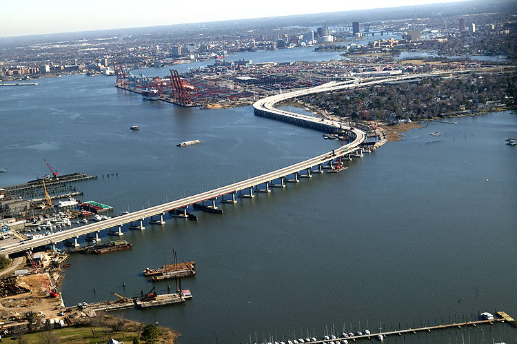 |
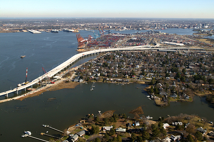
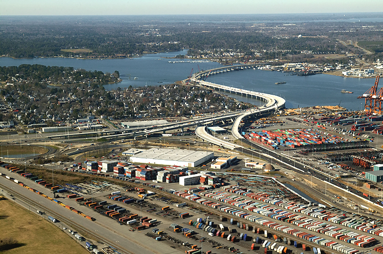
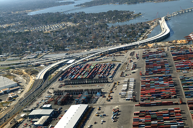
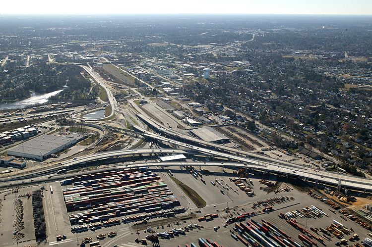
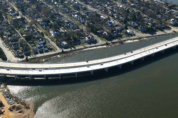
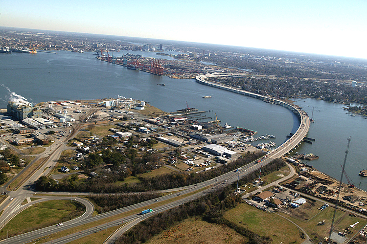
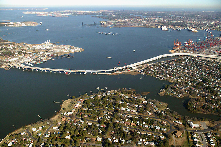
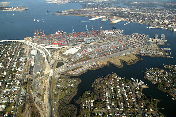
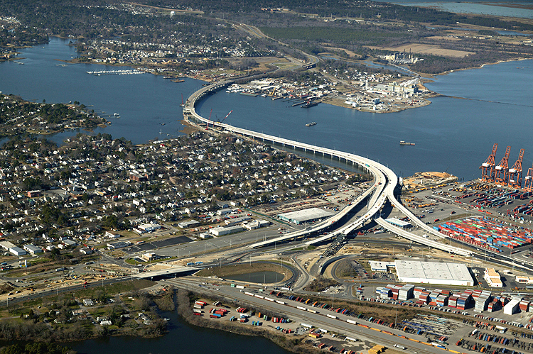
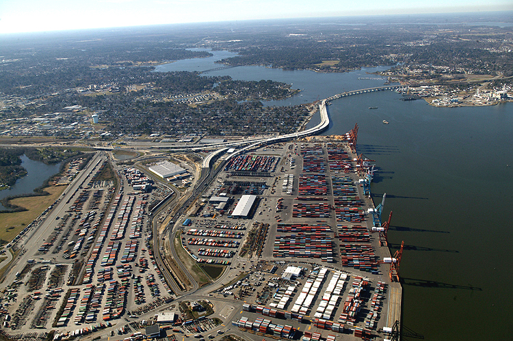
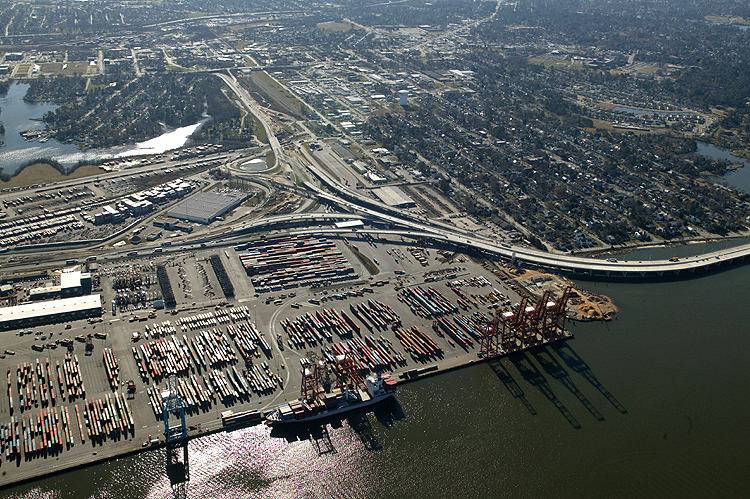
VA-164 Western Freeway crosses West Norfolk (a section of the city of Portsmouth) shoreline on lower left, onto the West Norfolk Bridge, passes across the Elizabeth River Western Branch, joins new Port Norfolk Connector freeway bridge, passes by the Port Norfolk neighborhood of Portsmouth, enters Pinners Point Interchange under construction. Portsmouth Marine Terminal on upper left, with downtown Norfolk and downtown Portsmouth in the distance in the upper center of the photo. Looking east. |
 |
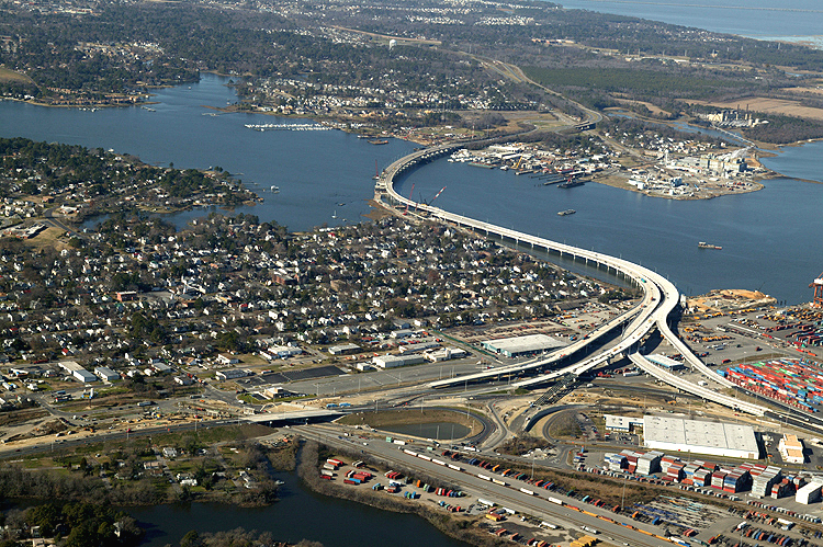
VA-164
Western Freeway crosses West Norfolk shoreline on lower left, onto the West
Norfolk Bridge, passes across the Elizabeth River Western Branch, joins new
Port Norfolk Connector freeway bridge, passes by the Port Norfolk neighborhood
of Portsmouth, enters Pinners Point Interchange under construction. Portsmouth
Marine Terminal on upper left, with downtown Norfolk and downtown Portsmouth
in the distance in the upper center of the photo. Looking east. The VA-164 freeway no longer provides highway access between the West Norfolk Bridge and the Port Norfolk neighborhood. The new Pinners Point Interchange will provide full local access to all three legs of the freeway complex, just east of the Port Norfolk neighborhood. It was the main consensus among the citizens in the Port Norfolk neighborhood, to restrict access so as to eliminate the through traffic, which comprised about 80% of the traffic that formerly passed through the neighborhood. |
 |
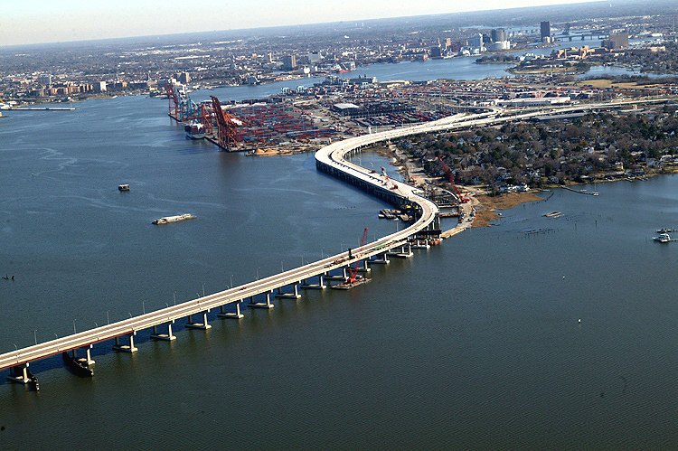
VA-164 Western Freeway crosses West Norfolk shoreline on left, onto the West Norfolk Bridge, passes across the Elizabeth River Western Branch, seamlessly joins new Port Norfolk Connector freeway bridge, passes by the Port Norfolk neighborhood of Portsmouth, enters Pinners Point Interchange under construction. The main portion of the Elizabeth River and Norfolk is in the background. Looking northeast. |
 |
West Norfolk Bridge and Elizabeth River Western Branch in foreground. The land area to the left where the pre-existing West Norfolk Bridge connects to, is the West Norfolk section of Portsmouth. Looking north. |
 |
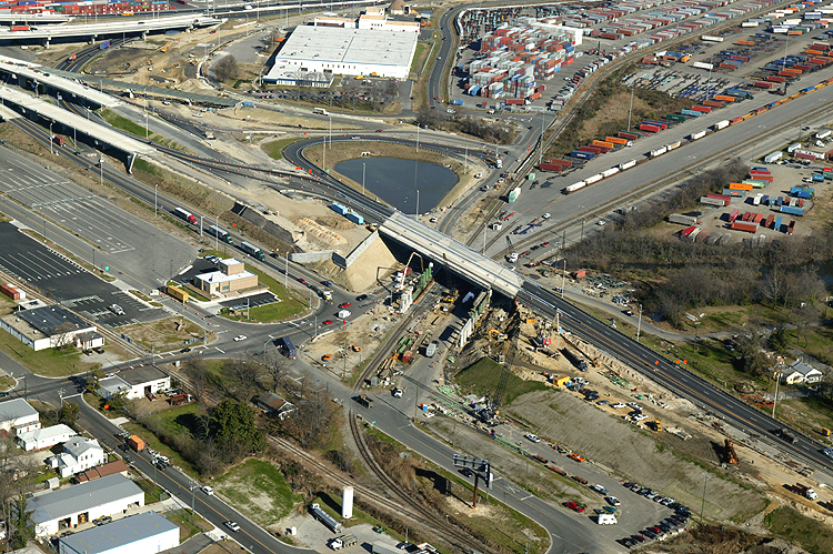
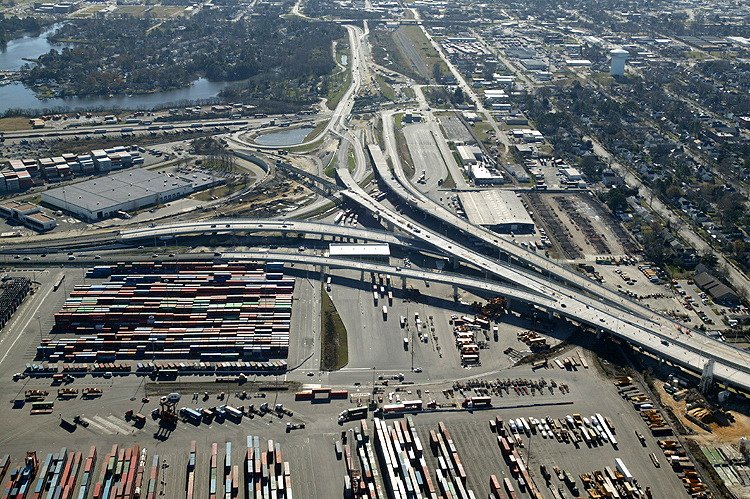
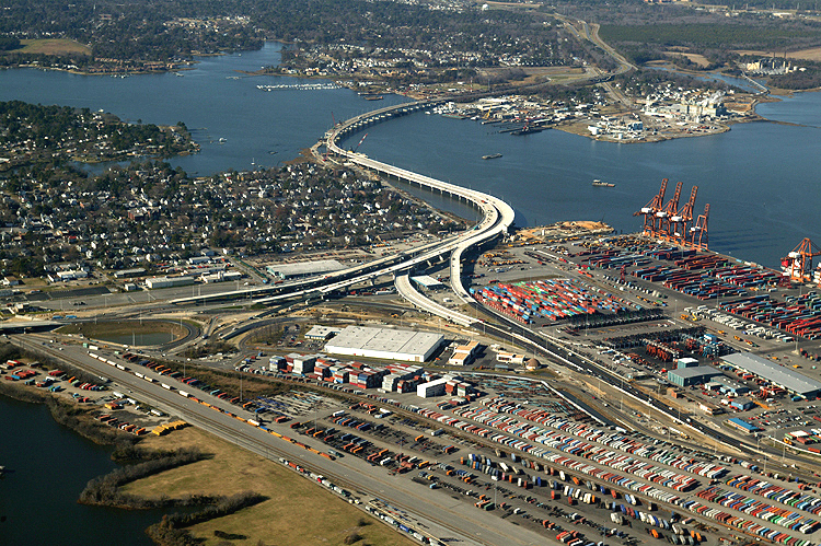
Pinners Point Interchange construction in center of photo, with Port Norfolk neighborhood in center of photo, with marine terminal in upper center of photo, with Port Norfolk Connector bridge under construction and Elizabeth River Western Branch in the left center, with downtown Norfolk in the distance in the upper center of the photo. Looking east. |
 |
Pinners Point Interchange construction in center of photo, with Port Norfolk neighborhood in lower center of photo, with marine terminal in upper left of photo, with Port Norfolk Connector bridge under construction in the left center, with downtown Norfolk in the distance in the upper center of the photo. Looking east. |
 |
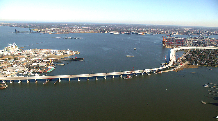
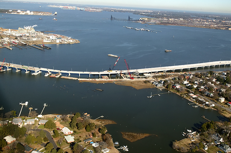
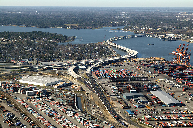
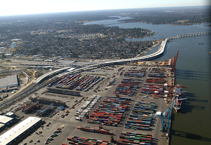
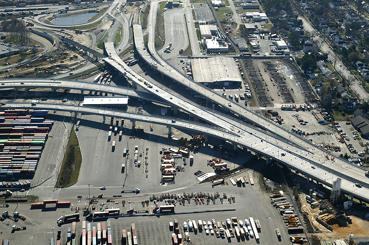
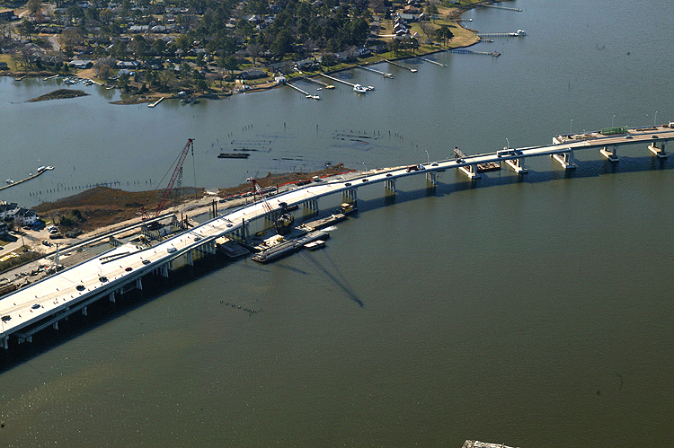
Port Norfolk Connector freeway bridge under construction in center of photo, with main section of the Elizabeth River in upper part of photo. The eastern 1,200 feet of the 3,630-foot-long West Norfolk Bridge is being reconstructed and realigned slightly northward so that it will make a seamless freeway connection with the new Port Norfolk Connector bridge. Looking north. The extension of the VA-164 West Norfolk Bridge, the Port Norfolk Connector bridge, is open to traffic with 2-lane 2-way traffic on portions of the new westbound bridge and the new eastbound bridge. The original 4-lane West Norfolk Bridge that opened to traffic in 1979, has 2-lane 2-way traffic temporarily using the 2-lane westbound roadway of the original bridge, with the 2-lane eastbound roadway temporarily closed and its seamless connection to the eastbound Port Norfolk Connector bridge under construction. |
 |
Port Norfolk neighborhood in right center of photo, with new Port Norfolk Connector freeway bridge under construction in center of photo, with main section of the Elizabeth River in upper part of photo. The south end of the West Norfolk Bridge is being reconstructed and realigned so that it will make a seamless freeway connection with the Port Norfolk Connector bridge. Looking north. |
 |
Pinners Point Interchange construction in center of photo, with Port Norfolk neighborhood in lower center of photo, with marine terminal in upper left of photo, with Port Norfolk Connector bridge under construction in the left center, with downtown Norfolk in the distance in the upper center of the photo. Looking east. |
 |
Port Norfolk Connector freeway bridge under construction in left center of photo, with Pinners Point Interchange construction in center of photo, with the marine terminal in upper part of photo, with MLK Freeway widening in lower right of photo, with Port Norfolk neighborhood in lower left part of photo, with main section of the Elizabeth River in upper part of photo, with Cleveland Street bridge construction in right center of photo. Looking north. |
 |
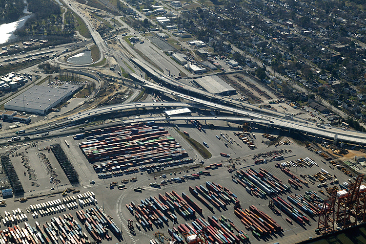
The Martin Luther Freeway passes over Cleveland Street, and the MLK Freeway overpass bridges are being replaced with longer and wider bridges, and 2-lane 2-way traffic is temporarily being maintained over the new northbound bridge over the MLK Freeway. Part of the Pinners Point Interchange construction can be seen in the upper left of the photo. The truck entrance to the marine terminal can be seen in the center left of the photo, and the temporary 2-lane 2-way terminus of the VA-164 Western Freeway can be seen just below the Cleveland Street bridge construction. This photo is from a similar vantage point as the previous photo, but zoomed in on the Cleveland Street overpass. |
 |
Port Norfolk Connector freeway bridge under construction in left center of photo, with Pinners Point Interchange construction in center of photo, with the marine terminal in upper part of photo, with MLK Freeway widening in lower right of photo, with Port Norfolk neighborhood in left part of photo, with main section of the Elizabeth River in upper part of photo, with new Cleveland Street bridge construction in lower left of photo. Looking north. |
 |
Port Norfolk Connector freeway bridge under construction in left center of photo, with Pinners Point Interchange construction in center of photo, with the marine terminal in right of photo, with MLK Freeway widening in lower left of photo, with Port Norfolk neighborhood in left part of photo, with main section of the Elizabeth River in upper part of photo. Looking northwest. |
 |
Port Norfolk Connector freeway bridge under construction in center of photo, with Pinners Point Interchange construction in center of photo, with the marine terminal in right of photo, with MLK Freeway widening in left of photo, with Port Norfolk neighborhood in left part of photo, with Elizabeth River Western Branch in upper part of photo. Looking west. |
 |
Port Norfolk Connector freeway bridge under construction in center of photo, with Pinners Point Interchange construction in center of photo, with the marine terminal in right of photo, with MLK Freeway widening in left of photo, with Port Norfolk neighborhood in left part of photo, with Elizabeth River Western Branch in upper part of photo. The asphalt highway in the center foreground, is the Midtown Tunnel approach highway. Looking west. |
 |
Port Norfolk Connector freeway bridge under construction in center of photo, with Pinners Point Interchange construction in center of photo, with the marine terminal in right of photo, with MLK Freeway widening in left of photo, with Port Norfolk neighborhood in upper left part of photo, with Elizabeth River Western Branch in upper part of photo, with the Midtown Tunnel approach highway in the lower left of the photo. Looking west. |
 |
Port Norfolk Connector freeway bridge under construction in upper right of photo, with Pinners Point Interchange construction in center of photo, with the marine terminal in right of photo, with MLK Freeway widening in left of photo, with Port Norfolk neighborhood in upper left part of photo, with Elizabeth River Western Branch in upper part of photo, with the Midtown Tunnel approach highway in the lower left of the photo. Looking west. |
 |
Pinners Point Interchange construction in center of photo, with the marine terminal in right of photo, with MLK Freeway widening in left of photo, with Port Norfolk neighborhood in upper part of photo, with the Midtown Tunnel approach highway in the lower left of the photo. Looking west. |
 |
Port Norfolk Connector freeway bridge under construction in upper right of photo, with Pinners Point Interchange construction in center of photo, with the marine terminal in right of photo, with MLK Freeway widening in left of photo, with Port Norfolk neighborhood in upper left part of photo, with Elizabeth River Western Branch in upper part of photo, with the Midtown Tunnel approach highway in the lower left of the photo. The Portsmouth Marine Terminal fronts on the main section of the Elizabeth River. Looking west. |
 |
Pinners Point Interchange construction in center of photo, with the marine terminal in lower part of photo, with MLK Freeway widening in upper left of photo, with Port Norfolk neighborhood in upper right of photo, with the Midtown Tunnel approach highway in the lower left of the photo. Looking southwest. |
 |
Pinners Point Interchange construction in center of photo, with the marine terminal in lower part of photo, with MLK Freeway widening in upper left of photo, with Port Norfolk neighborhood in upper right of photo, with the Midtown Tunnel approach highway in the lower left of the photo. Looking south. |
 |
Pinners Point Interchange construction in center of photo, with the marine terminal in lower part of photo, with MLK Freeway widening in upper left of photo, with Port Norfolk neighborhood in upper right of photo. The Pinners Point Interchange crosses over the Portsmouth Marine Terminal property. Looking south. |
 |
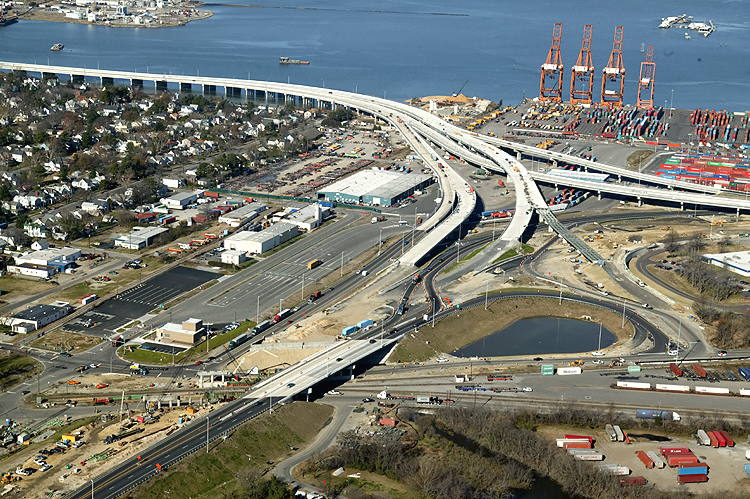
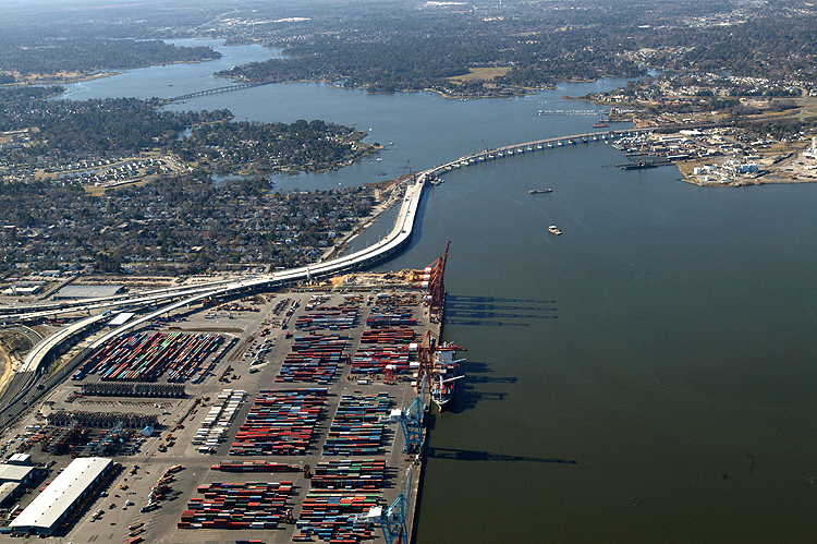
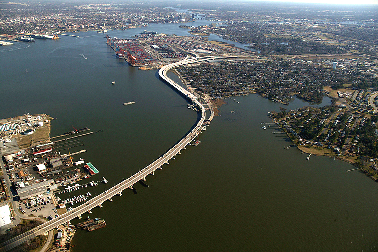
The new Port Norfolk Connector freeway bridge, as it crosses the shoreline out onto the Elizabeth River, with the Port Norfolk neighborhood in upper right of photo. Looking south. |
 |
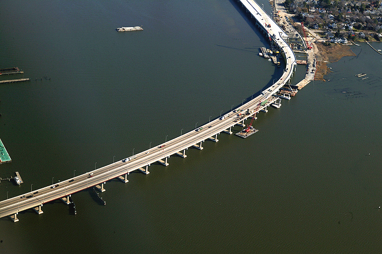
The new Port Norfolk Connector freeway bridge, as it crosses the shoreline out onto the Elizabeth River, with the Port Norfolk neighborhood in upper part of the photo. Temporarily, 2-lane 2-way VA-164 traffic is operating on the eastbound bridge, and one lane of westbound traffic is operating on the westbound bridge connecting the Midtown Tunnel to the VA-164 Western Freeway westbound to Churchland. The Port Norfolk Connector freeway bridge will have 6 lanes (3 each way) and full emergency shoulders when complete. Looking south. |
 |
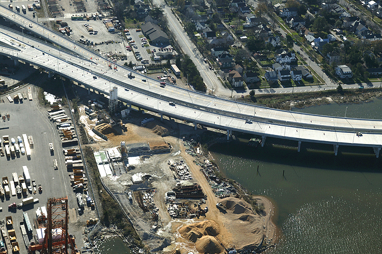
The south end of the West Norfolk Bridge is being reconstructed and realigned so that it will make a seamless freeway connection with the Port Norfolk Connector bridge. The eastern 1,200 feet of the 3,630-foot-long West Norfolk Bridge is being reconstructed and realigned slightly northward so that it will make a seamless freeway connection with the new Port Norfolk Connector bridge. Looking south. |
 |
Pinners Point Interchange construction in upper left of photo, with Port Norfolk Connector bridge under construction and Elizabeth River in the lower left, with Port Norfolk neighborhood in center of photo. Looking southeast. |
 |
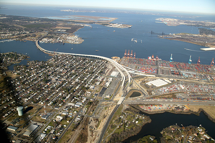
VA-164 Western Freeway crosses West Norfolk (a section of the city of Portsmouth) shoreline, onto the West Norfolk Bridge, passes across the Elizabeth River Western Branch, seamlessly joins new Port Norfolk Connector freeway bridge, passes by the Port Norfolk neighborhood of Portsmouth, enters Pinners Point Interchange under construction. Looking southeast. |
 |
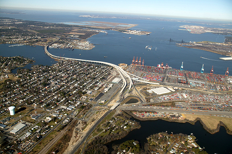
VA-164 Western Freeway crosses West Norfolk shoreline, onto the West Norfolk Bridge, passes across the Elizabeth River Western Branch, seamlessly joins new Port Norfolk Connector freeway bridge, passes by the Port Norfolk neighborhood of Portsmouth, enters Pinners Point Interchange under construction, the marine terminal is in the upper left of the photo. Looking southeast. |
 |
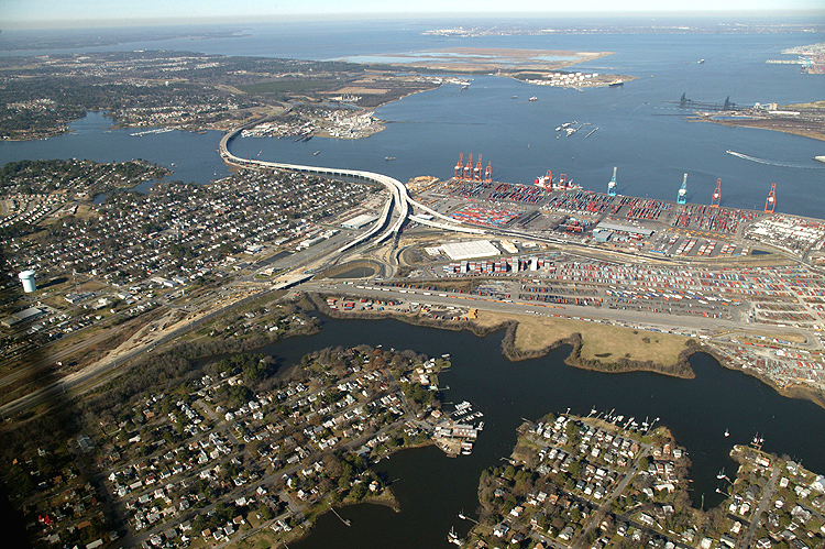
VA-164 Western Freeway crosses industrial West Norfolk shoreline, onto the West Norfolk Bridge, passes across the Elizabeth River Western Branch, seamlessly joins new Port Norfolk Connector freeway bridge, passes by the Port Norfolk neighborhood of Portsmouth, enters Pinners Point Interchange under construction. Looking southeast. |
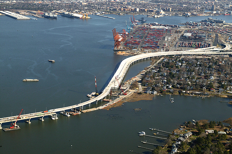 |
Port Norfolk Connector freeway bridge under construction in center of photo, with main section of the Elizabeth River in left part of photo. The eastern 1,200 feet of the 3,630-foot-long West Norfolk Bridge is being reconstructed and realigned slightly northward so that it will make a seamless freeway connection with the new Port Norfolk Connector bridge. Looking east. The extension of the VA-164 West Norfolk Bridge, the Port Norfolk Connector bridge, is open to traffic with 2-lane 2-way traffic on portions of the new westbound bridge and the new eastbound bridge. The original 4-lane West Norfolk Bridge that opened to traffic in 1979, has 2-lane 2-way traffic temporarily using the 2-lane westbound roadway of the original bridge, with the 2-lane eastbound roadway temporarily closed and its seamless connection to the eastbound Port Norfolk Connector bridge under construction. |
 |
Port Norfolk Connector freeway bridge under construction in left part of photo, with Pinners Point Interchange construction in center of photo, with the marine terminal in left part of photo, with MLK Freeway widening in right part of photo, with Port Norfolk neighborhood in center of photo, with Elizabeth River in left part of photo. Looking east. |
 |
Port Norfolk Connector freeway bridge under construction in left part of photo, with Pinners Point Interchange construction in center of photo, with the marine terminal in center of photo, with MLK Freeway widening in right part of photo, with Port Norfolk neighborhood in center of photo, with Elizabeth River in left part of photo, with downtown Norfolk in upper center of photo on opposite side of the river. Looking northeast. |
 |
Port Norfolk Connector freeway bridge under construction in left part of photo, with Pinners Point Interchange construction in center of photo, with the marine terminal in center of photo, with MLK Freeway widening in right part of photo, with Port Norfolk neighborhood in lower center of photo, with Elizabeth River in left part of photo, with downtown Norfolk in upper center of photo on opposite side of the river. Looking northeast. |
 |
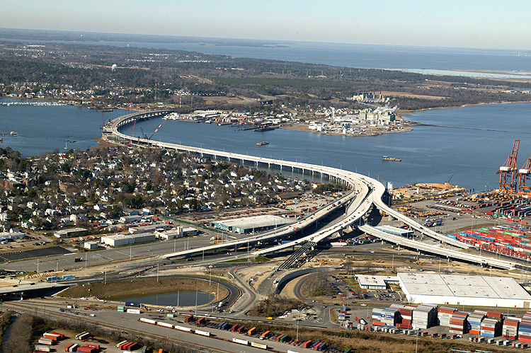
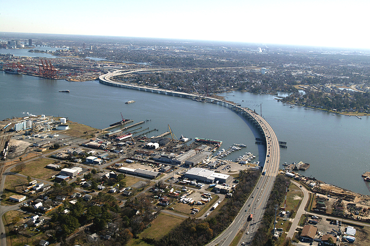
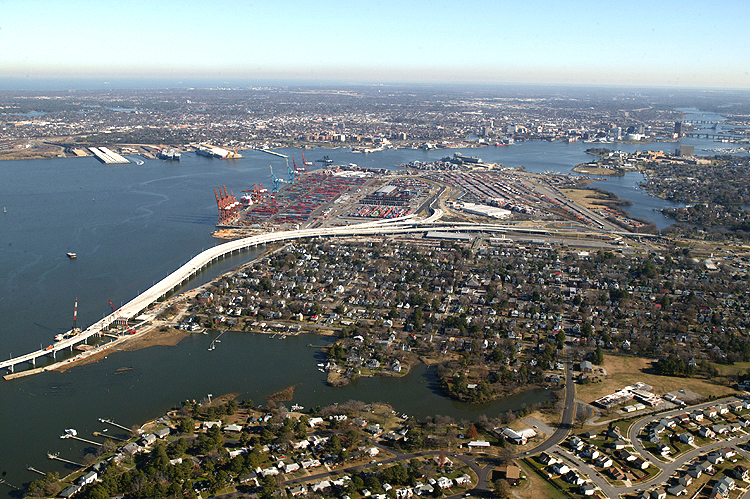
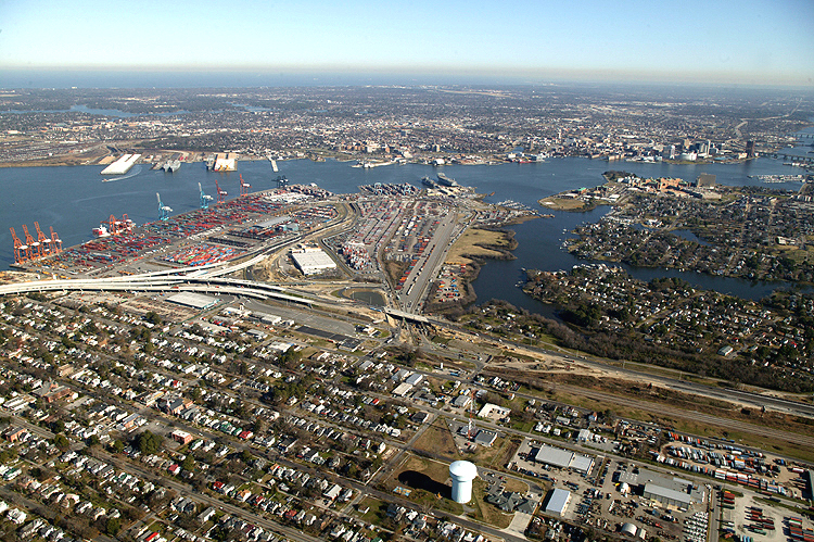
VA-164 Western Freeway crosses West Norfolk (a section of the city of Portsmouth) shoreline on left, onto the West Norfolk Bridge, passes across the Elizabeth River Western Branch, seamlessly joins new Port Norfolk Connector freeway bridge, passes by the Port Norfolk neighborhood of Portsmouth, enters Pinners Point Interchange under construction. Port Norfolk neighborhood in center right of photo, with Norfolk in upper center of photo on opposite side of the river, with Navy Base Norfolk and Norfolk International Terminals visible in the far distance in the upper left part of the photo. Looking north. |
 |
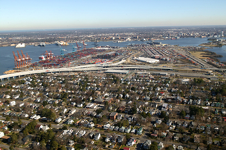
Pinners Point Interchange construction in left center of photo, with Port Norfolk neighborhood in lower center of photo, with marine terminal in upper left of photo, with downtown Norfolk in the distance in the center of the photo. Looking east. |
 |
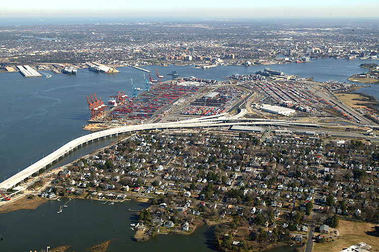
Port Norfolk Connector freeway bridge under construction in left center of photo, with Pinners Point Interchange construction in center of photo, with MLK Freeway widening in left part of photo, with Port Norfolk neighborhood in lower center of photo, with main section of the Elizabeth River in upper part of photo, with Norfolk in upper part of photo on opposite side of the river, with Navy Base Norfolk and Norfolk International Terminals visible in the far distance in the upper left part of the photo. Looking north. |
 |
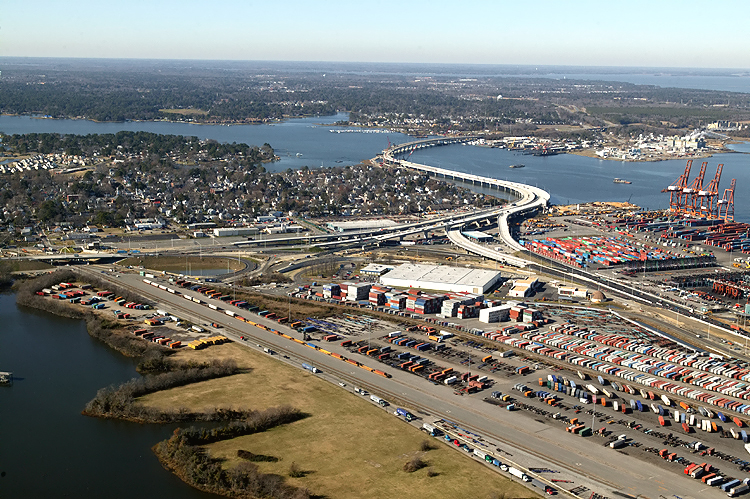
VA-164 Western Freeway crosses West Norfolk (a section of the city of Portsmouth) shoreline on left, onto the West Norfolk Bridge, passes across the Elizabeth River Western Branch, seamlessly joins new Port Norfolk Connector freeway bridge, passes by the Port Norfolk neighborhood of Portsmouth, enters Pinners Point Interchange under construction. Port Norfolk neighborhood in lower center of photo, with main section of the Elizabeth River in upper part of photo, with Norfolk in upper right part of photo on opposite side of the river, with Navy Base Norfolk and Norfolk International Terminals visible in the distance in the upper center part of the photo. Near the horizon, the Peninsula cities of Hampton and Newport News are partly visible, and the Hampton Roads estuary separates them from Norfolk and Portsmouth, and Craney Island is visible extending north from West Norfolk. Looking north. |
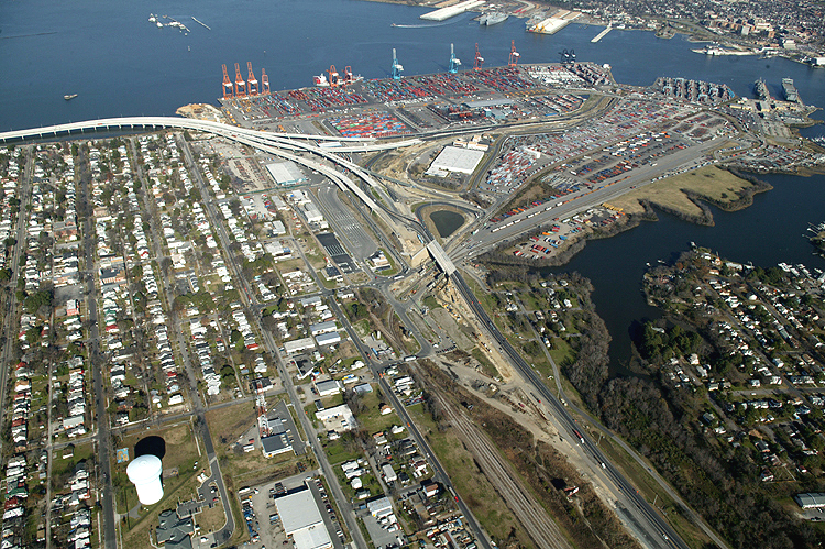 |
Port Norfolk Connector freeway bridge under construction in upper left part of photo, with Pinners Point Interchange construction in center of photo, with the marine terminal in upper part of photo, with MLK Freeway widening in lower right of photo, with Port Norfolk neighborhood in lower left part of photo, with main section of the Elizabeth River in upper part of photo, with Cleveland Street bridge construction in center of photo. Looking north. |
 |
Port Norfolk Connector freeway bridge under construction in left center of photo, with Pinners Point Interchange construction in center of photo, with the marine terminal in upper part of photo, with MLK Freeway widening in lower right of photo, with Port Norfolk neighborhood in left part of photo, with main section of the Elizabeth River in upper part of photo, with new Cleveland Street bridge construction in lower left of photo. Looking north. |
 |
Port Norfolk Connector freeway bridge under construction in left part of photo, with Pinners Point Interchange construction in left center of photo, with the marine terminal in center of photo, with MLK Freeway widening in lower left part of photo, with Port Norfolk neighborhood in left part of photo left of the highway, with main section of the Elizabeth River in upper part of photo, with Norfolk on opposite of the river. Looking north. |
 |
VA-164 Western Freeway crosses West Norfolk (a section of the city of Portsmouth) shoreline on left, onto the West Norfolk Bridge, passes across the Elizabeth River Western Branch, seamlessly joins new Port Norfolk Connector freeway bridge, passes by the Port Norfolk neighborhood of Portsmouth, enters Pinners Point Interchange under construction. Portsmouth Marine Terminal in right center of photo, Port Norfolk neighborhood in lower center of photo, with main section of the Elizabeth River in upper part of photo, with Norfolk in upper right part of photo on opposite side of the river, with Navy Base Norfolk and Norfolk International Terminals visible in the distance in the upper left part of the photo. Near the horizon, the Peninsula cities of Hampton and Newport News are partly visible, and the Hampton Roads estuary separates them from Norfolk and Portsmouth, and Craney Island is visible extending north from West Norfolk. Looking north. |
 |
Similar vantage point to previous photo, slightly different perspective. |
 |
Similar vantage point to previous photo, slightly longer perspective. |
 |
VA-164 Western Freeway crosses West Norfolk (a section of the city of Portsmouth) shoreline on left, onto the West Norfolk Bridge, passes across the Elizabeth River Western Branch, joins new Port Norfolk Connector freeway bridge, passes by the Port Norfolk neighborhood of Portsmouth, enters Pinners Point Interchange under construction, MLK Freeway widening on lower left of photo, marine terminal on right of photo. Looking northwest. |
 |
Similar vantage point to previous photo, slightly different perspective. |
 |
Similar to previous photo, from more to the north. |
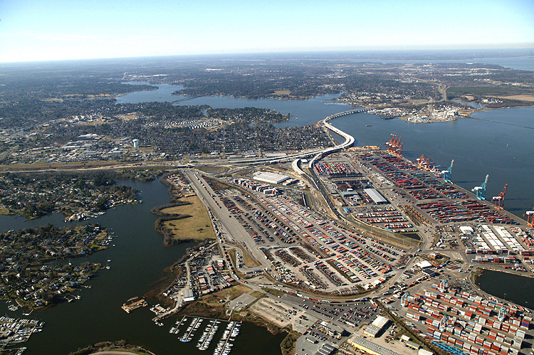 |
Pinners Point
Interchange (Port Norfolk Connector) project in distance, a wide-angle
view looking over the entire Portsmouth Marine Terminal area. Pinners
Point is the name of this entire point of land that is currently
industrialized. The Midtown Tunnel approach highway bisects the
industrialized area. Looking west.
|
 |
Similar to previous photo, from more to the north, from over the Elizabeth River shoreline. The Midtown Tunnel approach highway runs up-down in the lower center of the photo. Looking west. |
 |
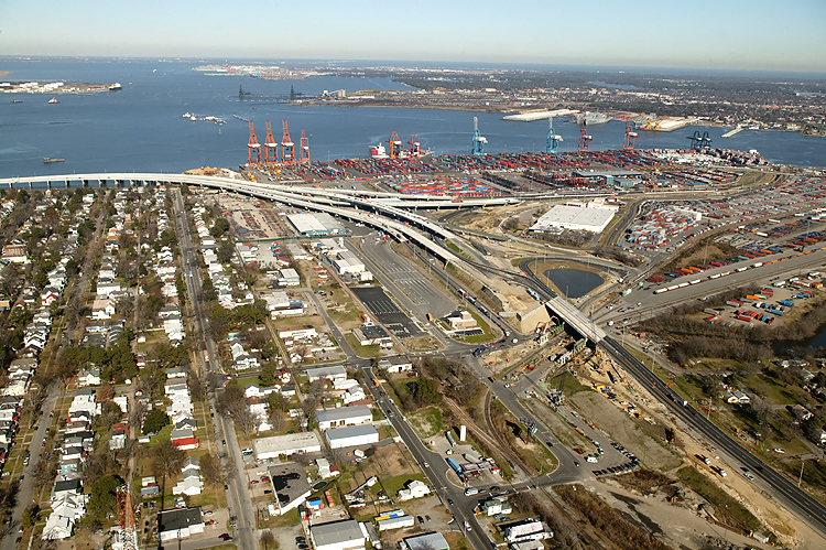
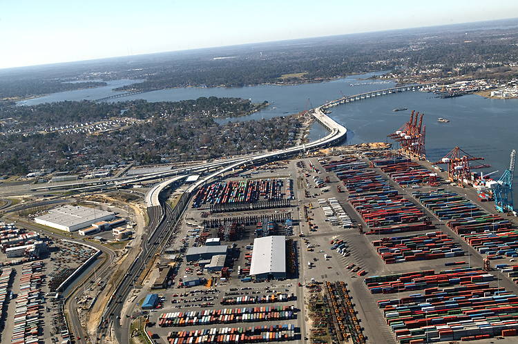
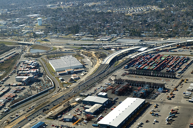
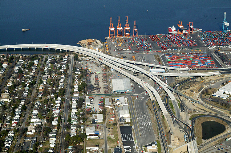
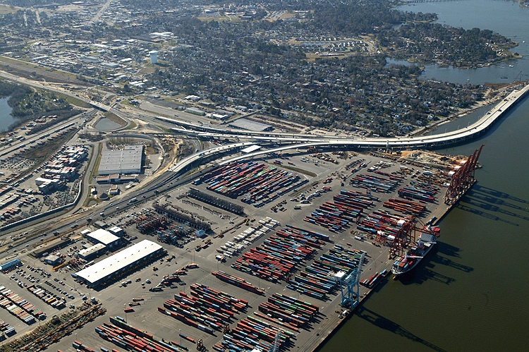
Port Norfolk Connector freeway bridge under construction in center of photo, with Pinners Point Interchange construction in left of photo, with the marine terminal in lower center of photo, with Port Norfolk neighborhood in center left part of photo, with Elizabeth River Western Branch in upper part of photo, with the Midtown Tunnel approach highway in the lower left of the photo. The marine terminal fronts on the main section of the Elizabeth River. Looking west. |
 |
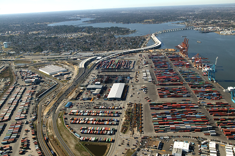
Pinners Point Interchange construction in center of photo, with the marine terminal in lower part of photo, with MLK Freeway widening in upper left of photo, with Port Norfolk neighborhood in upper center of photo, with the Midtown Tunnel approach highway in the lower left of the photo. Looking southwest. |
 |
Pinners Point Interchange construction in center of photo, with the marine terminal in lower part of photo, with MLK Freeway widening in upper left of photo, with Port Norfolk neighborhood in upper right of photo, with the Midtown Tunnel approach highway in the lower left of the photo. The Pinners Point Interchange crosses the marine terminal property. Looking southwest. |
 |
Similar vantage point to the previous photo, but zoomed out to a wider angle |
 |
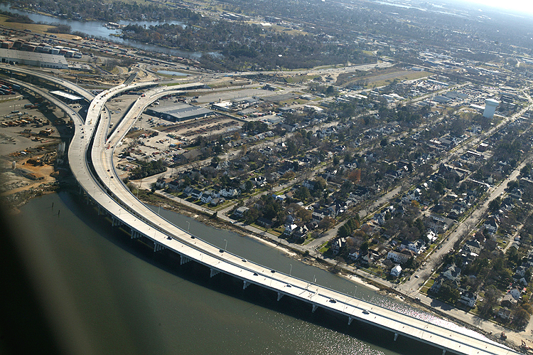
VA-164 Western Freeway crosses West Norfolk (a section of the city of Portsmouth) shoreline on lower left, onto the West Norfolk Bridge, passes across the Elizabeth River Western Branch, joins new Port Norfolk Connector freeway bridge, passes by the Port Norfolk neighborhood of Portsmouth, enters Pinners Point Interchange under construction. Portsmouth Marine Terminal in upper center, with downtown Norfolk and downtown Portsmouth in the distance in the upper center of the photo. Looking east. |
 |
VA-164 Western Freeway crosses West Norfolk (a section of the city of Portsmouth) shoreline on lower left, onto the West Norfolk Bridge, passes across the Elizabeth River Western Branch, joins new Port Norfolk Connector freeway bridge, passes by the Port Norfolk neighborhood of Portsmouth. The eastern 1,200 feet of the 3,630-foot-long West Norfolk Bridge is being reconstructed and realigned slightly northward so that it will make a seamless freeway connection with the new Port Norfolk Connector bridge. The extension of the VA-164 West Norfolk Bridge, the Port Norfolk Connector bridge, is open to traffic with 2-lane 2-way traffic on portions of the new westbound bridge and the new eastbound bridge. The original 4-lane West Norfolk Bridge that opened to traffic in 1979, has 2-lane 2-way traffic temporarily using the 2-lane westbound roadway of the original bridge, with the 2-lane eastbound roadway temporarily closed and its seamless connection to the eastbound Port Norfolk Connector bridge under construction. |
Lead article Parallel Midtown Tunnel / Pinners Point Interchange / Martin Luther King Freeway Extension
Copyright © 2005 by Scott Kozel. All rights reserved. Reproduction, reuse, or distribution without permission is prohibited.
By Scott M. Kozel, Roads to the Future
(Created 5-1-2005, files moved to pennways on 2-1-2006)